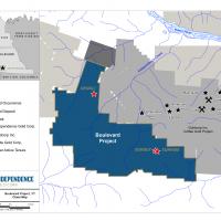
~19,960 hectares
958 claims
Orogenic-style gold mineralization
Access is by helicopter or by fixed-wing aircraft
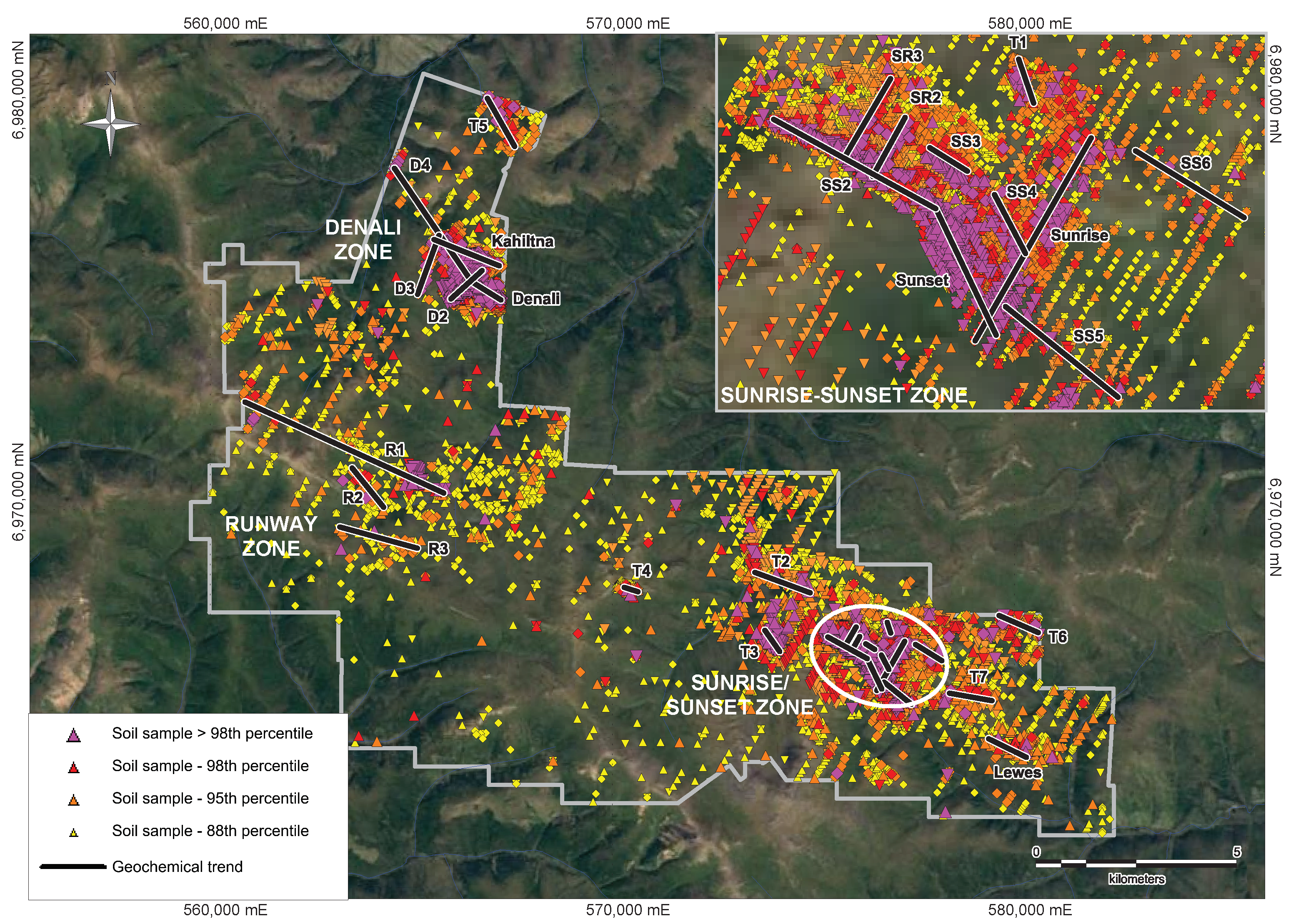
Independence Gold has discovered 25 soil geochemical anomalies, many of which occur in three main gold zones, the Sunrise/Sunset Zone, the Denali Zone and the Runway Zone, on its 100% owned Boulevard Project. Both the Sunrise/Sunset and the Denali Zones have been confirmed by drilling. The Company completed a 977.5 metre ("m") (9 holes) diamond drill program in 2017 on the Sunrise/Sunset Zone, following-up on reverse circulation ("RC") drill results from 2015 and 2016. The company has identified a coarse gold "nugget effect" in some drill intervals, thus requiring further analysis. The Boulevard Project is located adjacent to Newmont's Coffee Gold Project in the prolific White Gold District of the Yukon.
The Boulevard Project covers an area of ground in the White Gold District of the Dawson Range that has been explored since the late 1960's. The first known work on the project was regional-scale, stream silt sampling in 1969 and 1970 completed by Archer Cathro, to target "Casino-style" copper-molybdenum porphyry deposits. Modern exploration began in 2006 when Rimfire Minerals Corporation and Northgate Minerals Corporation completed a regional silt sampling program across the Dawson Range in search of "Pogo-style" intrusion-related gold deposits. Exploration work by Independence Gold has identified 25 gold-in-soil anomalies (trends) many of which occur in three main zones: Sunrise/Sunset, Denali and the Runway Zone.
The following work has been completed as of November 2017:
| Boulevard | |
| Mapping/Prospecting | |
| Geophysics (line km) | 3,579 |
| Soil Sampling | 20,330 |
| Trenching (# (m)) | 21 (4,107 m) |
| Diamond Drilling (# (m)) | 46 (5,936 m) |
| Reverse Circulation Drilling (#(m)) | 51 (5,787 m) |
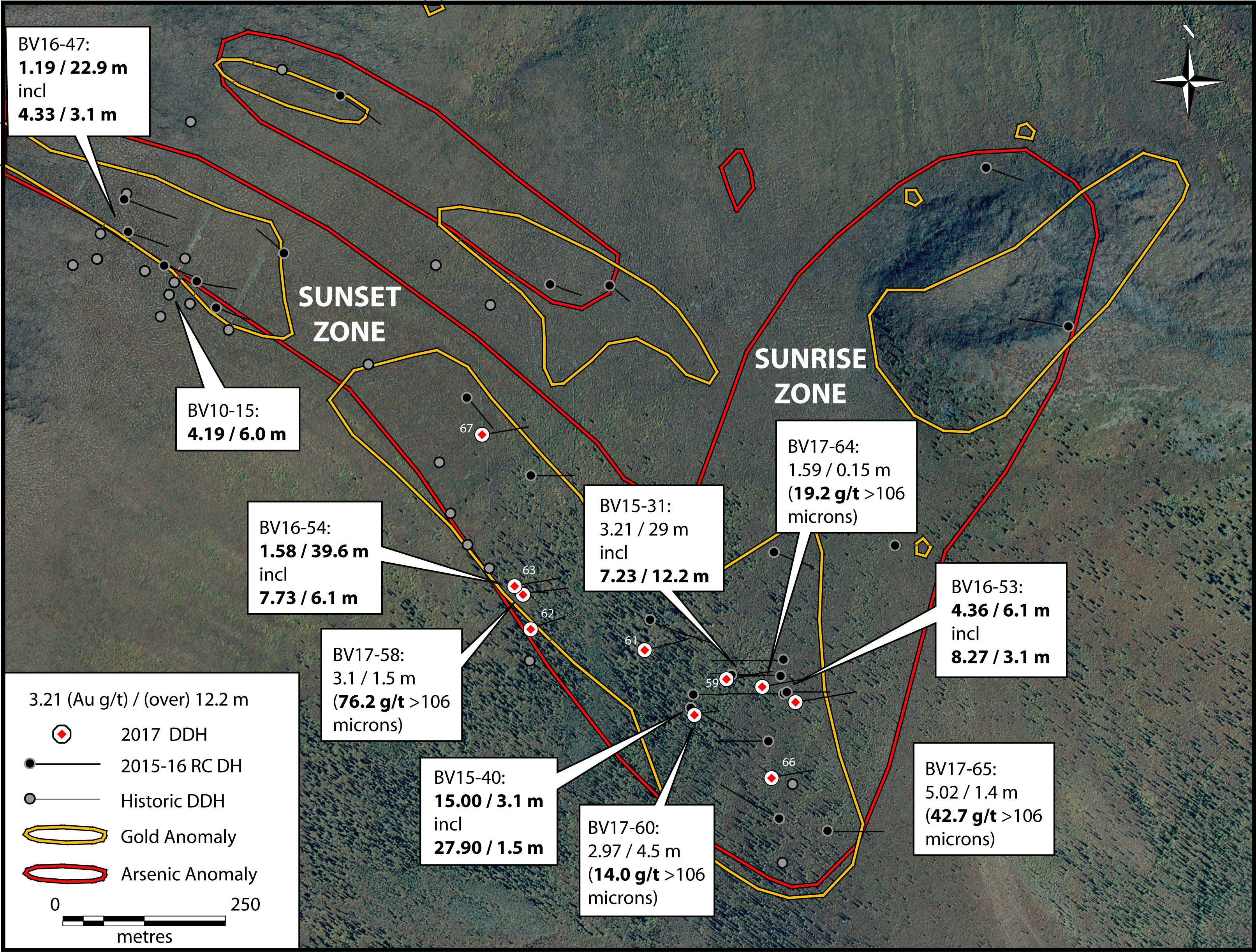
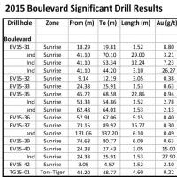
The Sunrise/Sunset Zone consists of multiple northeast and northwest-trending multi-element soil geochemical anomalies identified by gold-in-soil assay values ranging from below detection to 7,010 parts per billion (ppb) gold, with coincident arsenic and antimony. These features parallel mineralized trends at Goldcorp's Coffee deposit located 8.5 km northeast of the Sunrise Zone. Significant reverse circulation ("RC") drill intercepts that were followed up in 2017 are presented below:
| Drill hole | From (m) | To (m) | Length (m)* | Au (g/t) |
| BV15-31 | 18.3 | 19.8 | 1.5 | 8.80 |
| and | 41.1 | 70.1 | 29.0 | 3.21 |
| Incl. | 41.1 | 53.3 | 12.2 | 7.23 |
| Incl. | 41.1 | 54.2 | 3.1 | 26.27 |
| BV15-40 | 24.4 | 27.4 | 3.0 | 15.00 |
| Incl. | 24.4 | 25.9 | 1.5 | 27.90 |
| BV16-53 | 16.8 | 22.9 | 6.1 | 4.36 |
| Incl. | 18.3 | 21.3 | 3.1 | 8.27 |
| and | 50.3 | 59.4 | 9.2 | 0.36 |
| BV16-54 | 24.4 | 64.0 | 39.6 | 1.58 |
| Incl. | 24.4 | 30.5 | 6.1 | 7.73 |
*Lengths are apparent thicknesses of the mineralization and should not be considered true widths
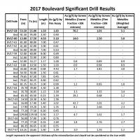
Significant intercepts from the 2017 diamond drill program include:
| Drill hole | From (m) | To (m) | Length (m) | Au (g/t) by Fire Assay | Au (g/t) by Screen Metallics (Coarse Fraction >106 microns) |
Au (g/t) by Screen Metallics (Fine Fraction <106 microns) |
Au (g/t) by Screen Metallics (Weighted Average) |
| BV17-58 | 53.5 | 55.0 | 1.5 | 3.10 | 76.20 | 1.01 | 3.1 |
| And | 91.5 | 95.0 | 3.5 | 0.40 | - | - | - |
| BV17-59 | 52.0 | 60.0 | 8.0 | 0.49 | - | - | - |
| BV17-60 | 13.0 | 17.5 | 4.5 | 2.97* | 14.03 | 2.56 | 3.0 |
| BV17-61 | 81.0 | 88.0 | 7.0 | 0.47 | - | - | - |
| BV17-62 | 41.0 | 42.0 | 1.0 | 0.61 | - | - | - |
| And | 92.0 | 99.0 | 7.0 | 0.10 | - | - | - |
| BV17-63 | 34.0 | 34.68 | 0.68 | 4.43 | 1.7 | 3.81 | 3.8 |
| And | 79.65 | 87.50 | 7.85 | 0.45 | - | - | - |
| BV17-64 | 35.7 | 39.0 | 3.3 | 1.38 | - | - | - |
| Incl | 35.7 | 36.85 | 1.15 | 3.3 | 3.3 | 3.35 | 3.4 |
| And | 65.35 | 65.50 | 0.15 | 1.59 | 19.2 | 0.68 | 1.2 |
| BV17-65 | 14.50 | 20.30 | 4.3 | 2.58 | - | - | - |
| Incl | 16.0 | 17.4 | 1.4 | 5.02 | 42.7 | 2.01 | 3.2 |
| Incl | 17.90 | 19.2 | 1.3 | 2.35 | 8.1 | 2.66 | 2.3 |
| And | 129.0 | 129.5 | 0.5 | 2.27 | 4.7 | 1.62 | 1.7 |
| BV17-66 | 77.15 | 77.50 | 0.35 | 2.69 | 1.8 | 2.76 | 2.7 |
| BV17-67 | 19.25 | 20.85 | 1.6 | 1.39 | 1.0 | 1.26 | 1.2 |
*Lengths are apparent thicknesses of the mineralization and should not be considered true widths
Three excavator trenches have been completed on the western extent of the Sunrise/Sunset Zone confirming the presence of bedrock gold mineralization. Trench BV08-01 intersected 2.93 g/t gold over 14 m including 6 m grading 6.79 g/t gold. Trench BV08-02, located 100 m southwest of BV08-01 intersected 4 m of 3.61 g/t gold. Trench BV08-03, located 200 m northwest of BV08-01, exhibited weakly anomalous gold mineralization across 5 m.
Based on the available data, the two primary controls on mineralization at Sunrise/Sunset are the presence of white massive quartz veins, comprising up to 80% of the rock and a resistive quartzite host rock. The sulphide mineral and quartz vein content, as well as the associated pathfinder element concentrations, vary significantly from one mineralized intercept to the next. These differences imply that a minimum of two separate, chemically distinct episodes of high grade gold mineralization have occurred at the Sunrise/Sunset Zone. Gold mineralization at the Sunrise/Sunset Zone appears to occur within north-northeast striking, steeply dipping structures with variable amounts of both sulphide minerals and vein quartz. Pyrite +/- arsenopyrite and stibnite are irregularly developed within mineralized zones and oxidation levels are variable to a depth of approximately 45 m.
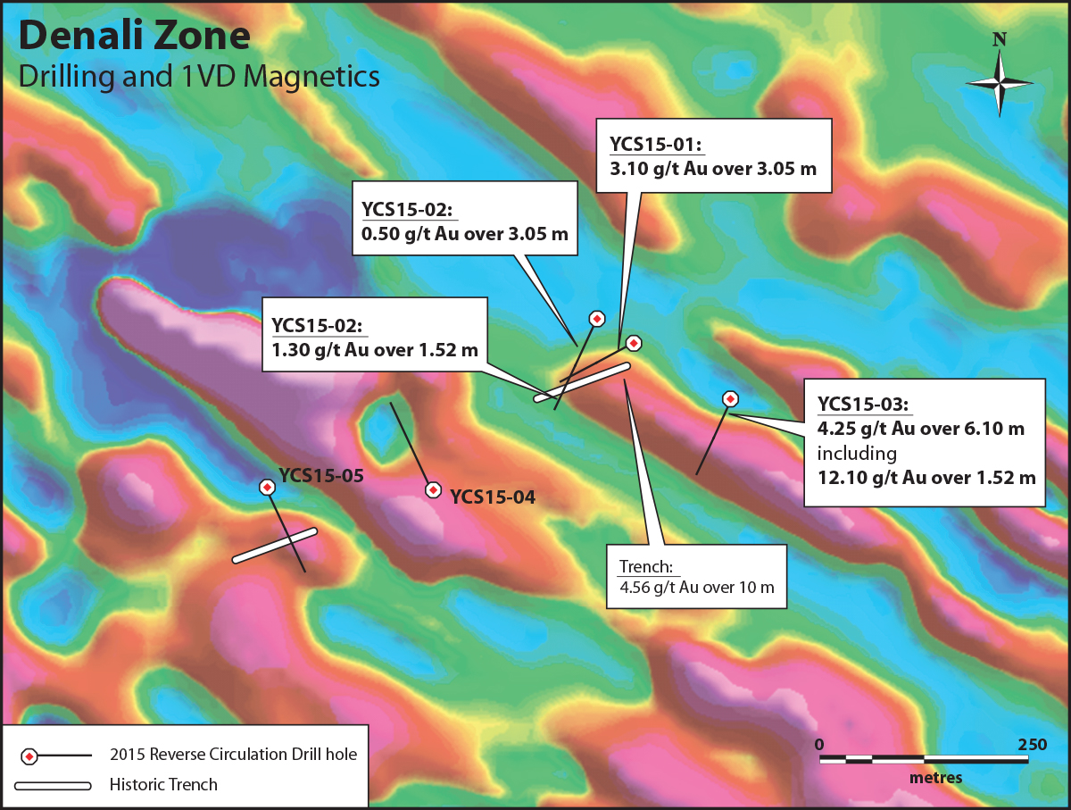
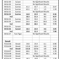
The Denali Zone is composed of 5 gold-in-soil anomalous trends ranging in length from 700 m to 3.3 km. These geochemical soil anomalies are identified by gold assay values ranging from below detection to 4,530 ppb gold with associated anomalous arsenic and antimony. Follow-up excavator trenching intersected 10 m of bedrock mineralization averaging 4.56 g/t gold. Subsequent follow-up RC drilling on the main Denali trend in 2015 and 2016 returned significant intercepts as presented below:
| Drill Hole | From (m) | To (m) | Length (m)* | Au (g/t) |
| YCS15-01 | 18.29 | 21.34 | 3.05 | 3.33 |
| YCS15-02 | 71.63 | 74.68 | 3.05 | 0.50 |
| and | 185.93 | 187.45 | 1.52 | 1.30 |
| YCS15-03 | 9.14 | 15.24 | 6.10 | 4.25 |
| incl. | 13.72 | 15.24 | 1.52 | 12.10 |
| YCS16-06 | 19.8 | 25.9 | 6.1 | 0.98 |
| YCS16-06 | 115.8 | 120.4 | 4.6 | 2.33 |
| Incl. | 115.8 | 117.4 | 1.5 | 6.35 |
| YCS16-07 | 68.6 | 70.1 | 1.5 | 1.78 |
| YCS16-08 | 99.1 | 103.6 | 4.6 | 4.28 |
| YCS16-10 | 18.3 | 19.8 | 1.5 | 1.20 |
| YCS16-11 | 24.4 | 29.0 | 4.6 | 0.95 |
| YCS16-12 | 7.6 | 10.7 | 3.1 | 1.94 |
| YCS16-16 | 39.6 | 59.4 | 19.8 | 0.47 |
| Incl. | 57.9 | 59.4 | 1.5 | 2.27 |
*Lengths are apparent thicknesses of the mineralization and should not be considered true widths
The mineralized zone beneath the main Denali trend appears to plunge moderately to the north-northeast, and is variably hosted within quartzite or quartz biotite schist, typically associated with an increase in fine grained pyrite. Similar to other mineralized zones in the White Gold District, mineralization is associated with elevated arsenic and antimony. In addition, select rock samples from prospecting have yielded assay values ranging from below detection to 9.74 g/t gold, with the three best rock samples assaying 9.74 g/t, 8.86 g/t and 7.88 g/t gold.
The Runway Zone is composed of 3 gold-in-soil anomalous trends ranging in length from 1.2 km to 5.4 km. These geochemical soil anomalies are identified by gold assay values ranging from below detection to 1,110 ppb gold with associated anomalous arsenic and antimony. This zone has not yet been tested by drilling or trenching.
Most of the Boulevard Project area is underlain by Yukon-Tanana Terrane metamorphic rocks. The Yukon-Tanana metamorphic package is intruded to the north and south by the Dawson Range Batholith, a mid-Cretacous hornblende-biotite granodiorite. The northern part of this batholith is comprised of undeformed biotite granite and garnet-bearing leucogranite that occur as elongate intrusions, conformable with the regional metamorphic fabric. Gold mineralization on the Boulevard Project is hosted by quartzite, biotite-chlorite schist and lesser chlorite-biotite schist crosscut by quartz and quartz-carbonate veins with locally sericite-altered envelopes. The gold mineralization at the Sunset Zone is controlled in part by a southwest-dipping, planar fault structure, and at the Sunrise Zone mineralization appears to be controlled by a steep, northeast trending fault structure. The mineralized zone at Denali trends northwest and dips to the northeast at a shallow to moderate angle, possibly along a fault structure.